
Abstract
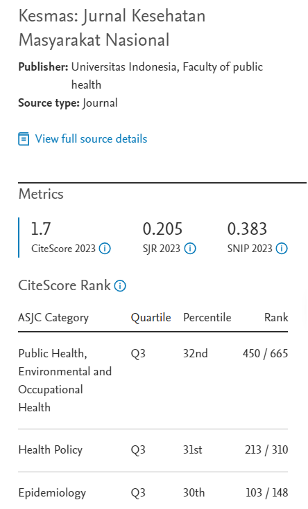
Indonesia is a vast country struggling to reduce its stunting prevalence. Hence, identifying priority areas is urgent. In determining areas to prioritize, one needs to consider geographical issues, particularly correlations among areas. This study aimed to discover whether stunting prevalence in Indonesia occurs randomly or in clusters; and, if it occurs in clusters, which areas are the hotspots. This ecological study used aggregate data from the 2018 National Basic Health Research and Poverty Data and Information Report from the Statistics Indonesia. This study analyzed 514 districts/cities across 34 provinces on seven main islands in Indonesia. The method used was the Euclidean distance to define the spatial weight. Moran's index test was used to identify autocorrelation, while a Moran scatter plot was applied to identify stunting hotspots. Autocorrelation was found among districts/cities in Sumatra, Java, Sulawesi, and Bali East Nusa Tenggara West Nusa Tenggara Islands, resulting in 133 districts/cities identified as stunting hotspots on four major islands. Autocorrelation proves that stunting in Indonesia does not occur randomly.
References
1. Kementerian Kesehatan Republik Indonesia. Laporan Nasional Riskesdas 2018. Jakarta: Badan Penelitian dan Pengembangan Kesehatan; 2019.
2. Tim Nasional Percepatan Penanggulangan Kemiskinan (TN2PK). Gerakan Nasional Pencegahan Stunting dan Kerjasama Kemitraan Multi Sektor. Jakarta: Sekretariat Wakil Presiden Republik Indonesia; 2018.
3. Hagos S, Hailemariam D, WoldeHanna T, Lindtjørn B. Spatial heterogeneity and risk factors for stunting among children under age five in Ethiopia: a Bayesian geo-statistical model. PLoS One. 2017; 12 (2): e0170785.
4. Alemu ZA, Ahmed AA, Yalew AW, Birhanu BS. Nonrandom distribution of child undernutrition in Ethiopia: spatial analysis from the 2011 Ethiopia demographic and health survey. Int J Equity Health. 2016; 15: 198.
5. Haile D, Azage M, Mola T, Rainey R. Exploring spatial variations and factors associated with childhood stunting in Ethiopia: spatial and multilevel analysis. BMC Pediatr. 2016; 16: 49.
6. Hernández-Vásquez A, Tapia-López E. Chronic malnutrition among children under five in Peru: a spatial analysis of nutritional data, 2010-2016. Rev Esp Salud Publica. 2017; 91: e201705035.
7. Development Initiatives Poverty Research. Global nutrition report 2018. Bristol: Development Initiatives Poverty Reasearch Ltd; 2018.
8. Di Cesare M, Bhatti Z, Soofi SB, Fortunato L, Ezzati M, Bhutta ZA. Geographical and socioeconomic inequalities in women and children's nutritional status in Pakistan in 2011: an analysis of data from a nationally representative survey. Lancet Glob Health. 2015; 3 (4): e229-39.
9. Bharti R, Dhillon P, Narzary PK. A spatial analysis of childhood stunting and its contextual correlates in India. Clin Epidemiol Glob Health. 2019; 7 (3): 488-95.
10. Yadav A, Ladusingh L, Gayawan E. Does a geographical context explain regional variation in child malnutrition in India? J Public Health. 2015; 23: 277-87.
11. Pawloski LR, Curtin KM, Gewa C, Attaway D. Maternal-child overweight/obesity and undernutrition in Kenya: a geographic analysis. Public Health Nutr. 2012; 15 (11): 2140-7.
12. Menon P, Headey D, Avula R, Nguyen PH. Understanding the geographical burden of stunting in India: a regression-decomposition analysis of district-level data from 2015-16. Matern Child Nutr. 2018; 14 (4): e12620.
13. Badan Perencanaan Pembangunan Nasional. Rancangan Teknokratik Rencana Pembangunan Jangka Menengah Nasional 2020-2024. Jakarta: Kementerian PPN/Bappenas; 2019.
14. World Health Organization. Global nutrition targets 2025: stunting policy brief. Geneva: WHO; 2014.
15. Myers RH. Classical and modern regression with applications. 2nd ed. Boston: Duxbury Press; 2020.
16. Pfeiffer D, Robinson T, Stevenson M, Rogers D, Clements A. Spatial analysis in epidemiology. Oxford: Oxford University Press; 2008.
17. Grekousis G. Spatial analysis methods and practice: describe, explore, explain through GIS. New York: Cambridge University Press; 2020.
18. Souris M. Epidemiology and Geography. London: John Wiley & Sons; 2019.
19. Fischer MM, Wang J. Spatial data analysis models, methods and Ttechniques. London New York: Springer; 2011.
20. Khan J, Mohanty SK. Spatial heterogeneity and correlates of child malnutrition in districts of India. BMC Public Health. 2018; 18: 1027.
21. Bhunia GS, Shit PK. Geospatial analysis of public health. Cham: Springer Nature; 2019.
22. Waller LA, Gotway CA. Applied spatial statistics for public health data. London: John Wiley & Sons; 2004.
23. Fotheringham AS, Rogerson PA. The SAGE handbook of spatial analysis. London: Sage; 2009.
24. Tim Nasional Percepatan Penanggulangan Kemiskinan (TN2PK). 100 kabupaten/kota prioritas untuk intervensi anak kerdil (stunting). Jakarta: Sekretariat Wakil Presiden Republik Indonesia; 2017.
25. Barankanira E, Molinari N, Msellati P, Laurent C, Bork KA. Stunting among children under 3 years of age in Côte d'Ivoire: spatial and temporal variations between 1994 and 2011. Public Health Nutr. 2017; 20 (9): 1627–39.
26. Spray AL, Eddy B, Hipp JA, Iannotti L. Spatial analysis of undernutrition of children in Léogâne Commune, Haiti. Food and Nutrition Bulletin (FNB). 2013; 34 (4): 444–61.
27. Adekanmbi VT, Uthman OA, Mudasiru OM. Exploring variations in childhood stunting in Nigeria using league table, control chart and spatial analysis. BMC Public Health. 2013; 13: 361.
28. Otterbach S, Rogan M. Exploring spatial differences in the risk of child stunting: evidence from a South African national panel survey. J. Rural Stud. 2018; 65: –78.
29. Hagos S, Lunde T, Mariam DH, Woldehanna T, Lindtjørn B. Climate change, crop production and child under nutrition in Ethiopia; a longitudinal panel study. BMC Public Health 2014; 14: 884.
30. Akseer N, Bhatti Z, Mashal T, Soofi S, Moineddin R, Black RE, Bhutta ZA. Geospatial inequalities and determinants of nutritional status among women and children in Afghanistan: an observational study. Lancet Glo. Health. 2018; 6 (4): e447–59.
31. Gerstman BB. Epidemiology kept simple. London: John Wiley & Sons; 2013.
Recommended Citation
Sipahutar T , Eryando T , Budiharsana M ,
et al.
Spatial Analysis of Seven Islands in Indonesia to Determine Stunting Hotspots.
Kesmas.
2022;
17(3):
228-234
DOI: 10.21109/kesmas.v17i3.6201
Available at:
https://scholarhub.ui.ac.id/kesmas/vol17/iss3/10
Included in
Biostatistics Commons, Environmental Public Health Commons, Epidemiology Commons, Health Policy Commons, Health Services Research Commons, Nutrition Commons, Occupational Health and Industrial Hygiene Commons, Public Health Education and Promotion Commons, Women's Health Commons